

US Rejects UN Move To Put Africa On True Scale
The United States has rejected a United Nations resolution encouraging the use of world maps that more accurately represent Africa’s actual size.
The resolution, sponsored by Togo and supported by African Union members, received 164 votes in favour at the UN General Assembly.
France and the United Kingdom supported the measure, while the United States was the only country to vote against it.
Estonia, Georgia, Lithuania, Moldova, Serbia and Ukraine abstained from the vote.
Although non-binding, the resolution encourages governments, schools, international organisations and technology companies to use maps showing continents and countries more accurately.
The campaign focuses on the Mercator projection, a map system created by Flemish cartographer Gerardus Mercator in 1569.
The projection preserves angles and directions, making it useful for navigation, but enlarges land masses located closer to the poles.
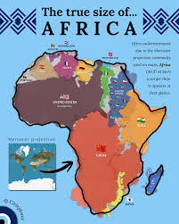
Consequently, Greenland can appear almost comparable in size to Africa on some world maps, despite Africa having roughly 14 times its land area.
Supporters say such distortions have influenced perceptions of Africa’s geographical importance, population, resources and economic potential.
The Equal Earth projection, developed in 2018, offers an alternative designed to represent the relative sizes of continents more accurately.
The African Union’s 54 member states adopted the projection in February, saying it better represents continental sizes, particularly Africa.
The #CorrectTheMap campaign has highlighted Africa’s vast landmass, saying several major countries and much of Europe could fit inside it.
Togo’s Foreign Minister, Robert Dussey, said the campaign sought to challenge perceptions created by distorted world maps.
“A fair world begins with a fair map,” Dussey said ahead of the General Assembly vote.
He argued that maps influence how people understand the place of continents and peoples in the world.
Dussey said a more accurate map would not change geography but would change how people perceive the world.
The resolution describes correcting cartographic distortions as an issue of “cognitive justice and memorial reparation.”
It recommends Equal Earth and other equal-area projections but does not prohibit the use of the Mercator projection.
The resolution also promotes education about the limitations involved in representing the spherical Earth on a flat surface.
French Foreign Minister Jean-Noël Barrot backed the initiative and said France planned to stop using Mercator maps.
Barrot said changing a map would not change the world, but correcting a distorted representation would be an act of truth.
The United States, however, said the General Assembly should concentrate on more urgent international challenges.
Yaryna Ferencevych, a US representative at the UN, said the resolution mocked the work and purpose of the General Assembly.
“Instead of focusing on genuine problems of international peace, prosperity, or good relations, this body is debating map projects from the 16th Century,” she said.
She also criticised references to reparations and “cognitive justice” contained in the resolution.
Washington described the broader framing of the proposal as ideological and questioned its relevance to the assembly’s priorities.
Ukraine supported efforts to address historical distortions affecting Africa and the Global South but raised concerns about some Equal Earth maps.
It specifically objected to how certain versions depict Ukrainian territories occupied by Russia.
Supporters insist the campaign goes beyond cartography and addresses how Africa has been represented and perceived globally.
Lerato Mogoatlhe of Africa No Filter described Africa’s map representation as a narrative issue rather than merely a cartographic error.
Kenyan geographer Kioko Muendo said maps shape how regions are perceived politically and economically.
Supporters believe wider use of equal-area projections will give people a clearer understanding of Africa’s enormous geographical scale.